DJI Mavic 3 Multispectral

Original price was: ₹600,000.00.Current price is: ₹544,999.00. inc. Gst

  • Net weight (with propellers and RTK module): 951 g
  • Maximum takeoff weight: 1,050 g
  • Folded dimensions (without propellers): 223×96.3×122.2 mm
  • Unfolded dimensions (without propellers): 347.5×283×139.6 mm
  • Diagonal length: 380.1 mm
  • Maximum ascent speed in Normal mode: 6 m/s
  • Maximum ascent speed in Sport mode: 8 m/s
  • Maximum descent speed: 6 m/s
  • Maximum flight speed in Normal mode: 15 m/s
  • Maximum forward speed in Sport mode: 21 m/s
  • Maximum sideways speed in Sport mode: 20 m/s
  • Maximum backward speed in Sport mode: 19 m/s
  • Maximum wind resistance: 12 m/s
  • Maximum takeoff altitude: 6000 m above sea level
  • Maximum flight time (no wind): approx. 43 minutes
  • Maximum hover time (no wind): approx. 37 minutes
  • Battery capacity: 5000 mAh LiPo 4S, 15.4 V nominal voltage
  • Remote Controller: DJI RC Pro with O3+ video transmission system
  • Max transmission range: up to 15 km in ideal conditions
  • RC Pro compatibility will expand to more DJI aircraft in future updates
SKU DJI-MAV3-MS Category Tags , Brand:

In stock

SHOP WITH CONFIDENCE

Description

DJI Mavic 3 Multispectral – The Ultimate Drone for Precision Agriculture and Environmental Monitoring

Imagine you’re a farmer in Punjab trying to monitor your fields from above. But your regular drone? It only gives you pretty pictures, no useful data. Enter the DJI Mavic 3 Multispectral, the drone that will not only give you stunning aerial shots but also the critical data you need to monitor crop health, soil conditions, and more. This isn’t just a drone; it’s a flying lab in the sky, designed to tackle precision agriculture like a pro. Think of it as your personal agricultural consultant but without the hefty fees or long meetings!

Let’s take a deeper dive into why the Mavic 3 Multispectral is more than just another pretty flying machine and how it can revolutionize the way you manage your land – whether you’re working on an orchard in Himachal or overseeing a massive farm in Madhya Pradesh.

Why This Drone Is a Game-Changer for Agriculture and Monitoring

Gone are the days of guessing whether your crops are healthy or stressing over soil conditions. With the Mavic 3 Multispectral, you get precision data straight to your phone or tablet. Whether you’re analyzing rice fields in Tamil Nadu or managing agroforestry projects in Kerala, this drone helps you keep track of everything with scientific accuracy.

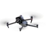
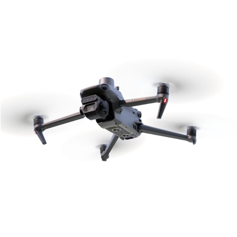
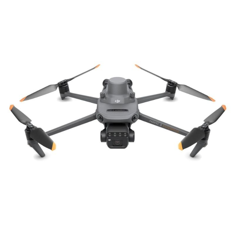
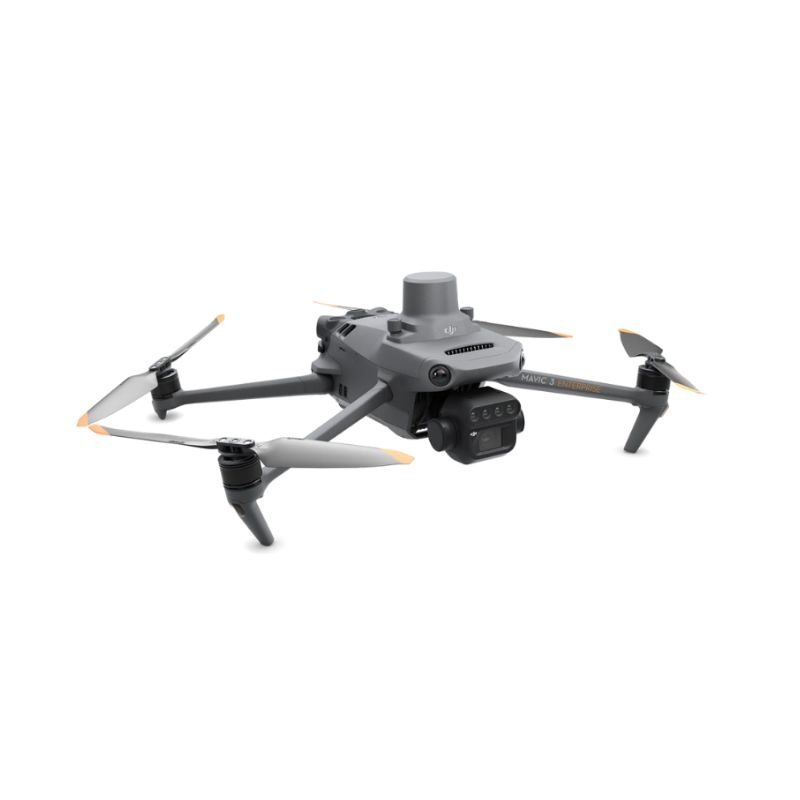
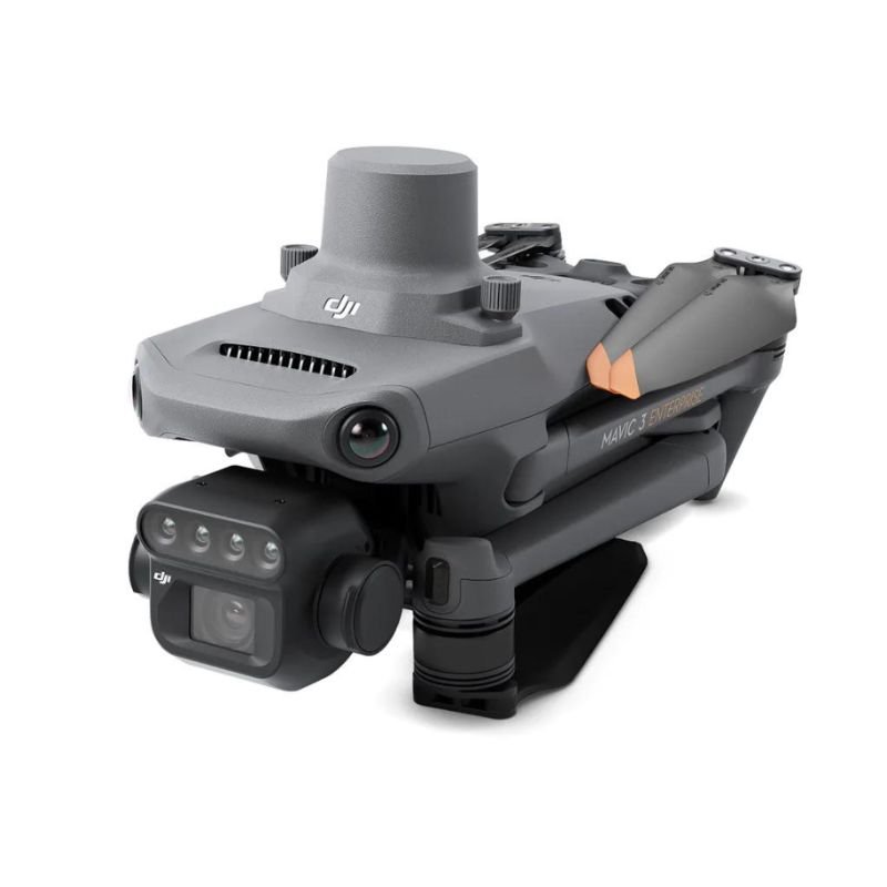
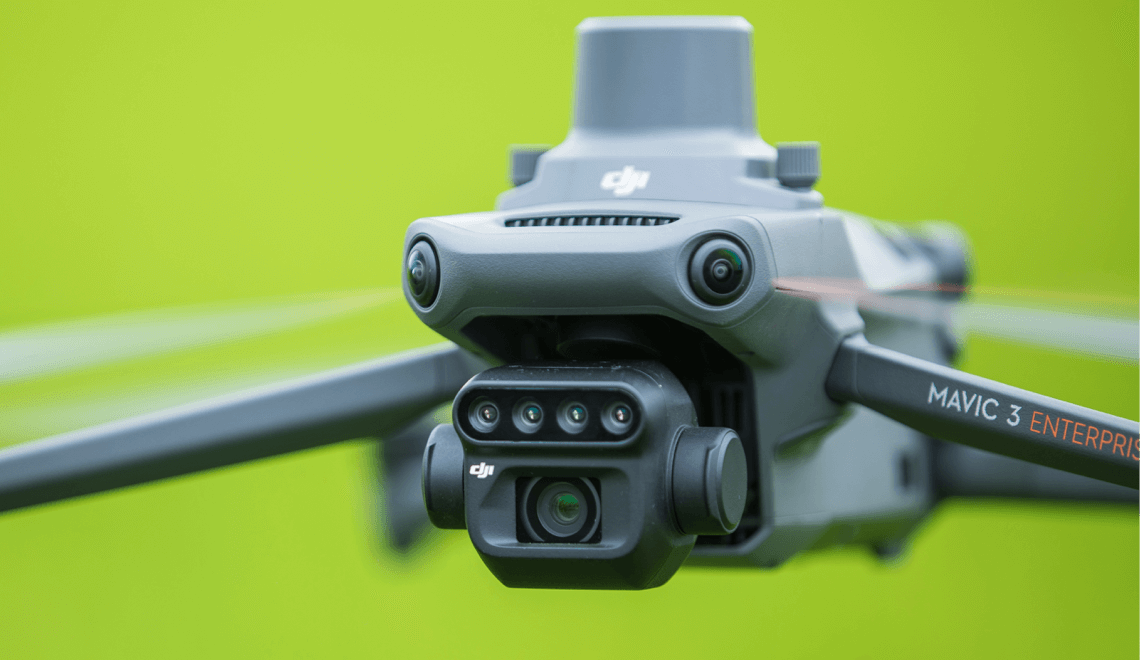
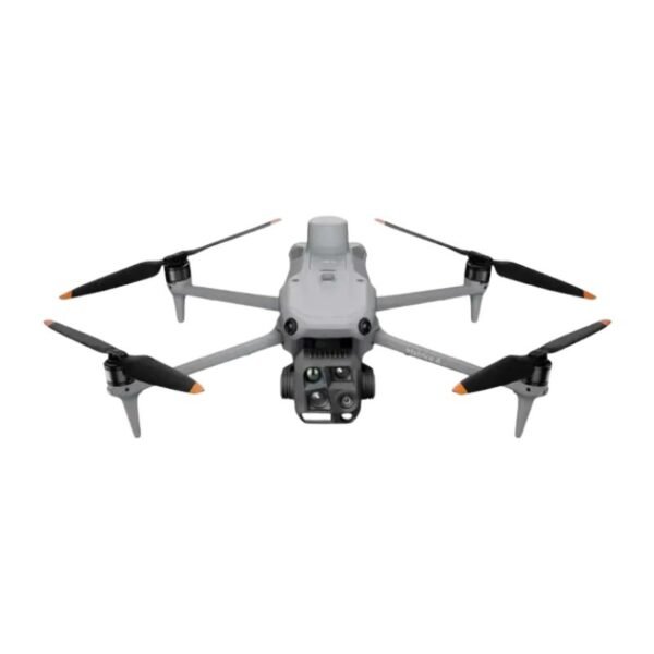
  • Multispectral Cameras: This drone packs five cameras, including RGB and multispectral lenses. This allows it to capture detailed data on plant health, water stress, and even soil conditions. It’s like having a drone that can “see” things beyond the human eye—talk about high-tech magic!

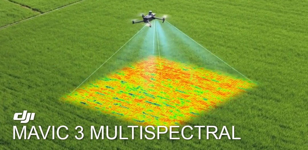
  • Real-Time NDVI Mapping: The Normalized Difference Vegetation Index (NDVI) feature gives you live insights into your crops’ health, so you can spot potential issues right away. It’s like checking your phone’s weather app, but for your crops – and trust us, your crops will thank you for it.

DJI Mavic 3 Multispectral camera

Simplicity in the Skies – Easy to Fly, Hard to Beat

Flying a drone should feel as easy as flipping a chapati, not like solving a jigsaw puzzle. Thankfully, the Mavic 3 Multispectral was designed for simplicity and precision. Whether you’re a first-time flyer or a seasoned drone pilot, this drone will make your life easier.

  • Easy-to-Use Controller: The DJI Smart Controller gives you an intuitive interface, so even if you’re not a tech wizard, you can fly with ease. Plus, the RTK (Real-Time Kinematic) system ensures centimeter-level accuracy for all your mapping and surveying. It’s like having a GPS that doesn’t take you through some random alley in the middle of nowhere!

  • Long Flight Time: The Mavic 3 Multispectral flies for up to 45 minutes. That means you can cover a lot of ground—whether you’re surveying rice paddies in Assam or scanning forests in Uttarakhand—without constantly worrying about battery life. It’s like being able to binge-watch your favorite series without pausing every 10 minutes to charge your phone.

Tough and Ready for Any Weather

India’s weather can change quicker than a Bollywood movie plot twist. Fortunately, the Mavic 3 Multispectral is built for it all. Whether it’s the blazing heat of Rajasthan or the heavy rains of Kerala, this drone keeps flying without breaking a sweat.

  • Weather Resistance: With an IP54 rating, this drone is dustproof and water-resistant. No more running indoors when the clouds roll in or the dust storm hits. It’ll keep working, and so will you.

Why Choose the DJI Mavic 3 Multispectral?

  • Powerful Data Capture: It’s not just a drone with cool flying abilities. It’s a data collection powerhouse, capturing multispectral imagery and NDVI maps for accurate crop analysis.

  • Simple, Efficient, and Accurate: Whether you’re new to drones or have been flying them since 2008, the Mavic 3 Multispectral makes precision flying and data capture easy. You’ll be able to monitor your fields in no time!

  • Built for Tough Conditions: You know how unpredictable India’s weather can be. With its weather-resistant build and long flight time, this drone is up for any challenge.

  • Surveying Made Simple: Need to map large areas quickly? The Mavic 3 Multispectral can cover up to 2.5 square kilometers per flight—saving you time and giving you data you can trust.

DJI Mavic 3 Multispectral scan the filed

Transform Your Farm or Environment Project with the DJI Mavic 3 Multispectral

Ready to make better decisions about your crops? Want to monitor forests, agriculture, or even mining sites with ease? The DJI Mavic 3 Multispectral is your ultimate tool for precision flying. Whether you’re managing fields in Punjab or environmental monitoring in Goa, this drone brings the power of advanced technology to your fingertips. Get your hands on the DJI Mavic 3 Multispectral today and take your agricultural game to the next level!

FAQ`s

Yes! The drone facilitates live NDVI mapping on the DJI RC Pro controller, so you will be in the field reviewing green (healthy) and red/yellow (stressed) zones live without waiting for post-processing. This drone would be useful where quick decisions are necessary for subsequent irrigation, spraying, etc.

The onboard RTK module allows centimeter-level accuracy (as low as 1 cm horizontal) and doesn't require an RTK base station in most scenarios. You can create accurate spraying maps or conduct boundary surveys on large farms.

A coverage of 2.5 square kilometers (250 hectares), at 120m altitude, can be captured in a single flight of 43 minutes. You can efficiently plan and collect data for a medium-sized farm in Punjab or Madhya Pradesh without changing a battery. 

Absolutely! It has an IP54 rating, which means it is both dustproof and splashproof. This drone can theoretically operate in light rain, the dusty winds of Rajasthan, and heat up to 40°C.  Just be careful of heavy rain and stormy winds
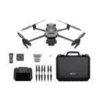
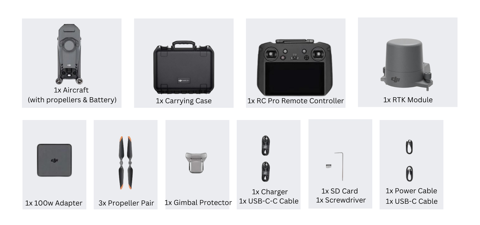
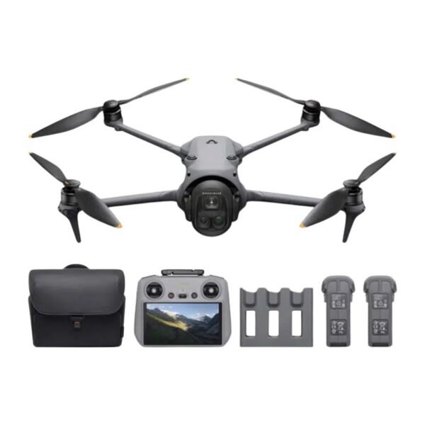
  • DJI Mavic 3 Multispectral Drone
  • DJI RC Pro Enterprise Controller (with a bright screen)
  • 3 x Intelligent Flight Batteries
  • RTK Module
  • Charger and cables
  • Propellers (6 pairs)
  • Carrying case
  • NDVI lens filter

'Full' Combo - fly out of the box!

Yes, according to DGCA rules, if you want to fly drones over 250g (and this is 1,050g) you will require:

  • UIN (Unique Identification Number)
  • UAOP (Unmanned Aircraft Operator Permit) for commercial use

We provide free assistance to register!

Specification


SpecificationDetails
Image Sensor4/3 CMOS
Effective Pixels20 MP
Lens FOV84°
Equivalent Focal Length24 mm
Aperturef/2.8 to f/11
Focus Range1 m to ∞
ISO Range100-6400
Shutter SpeedElectronic shutter: 8-1/8000 s
Mechanical shutter: 8-1/2000 s
Max Image Size5280×3956
Photo Shooting ModesSingle shot: 20 MP
Timed: 20 MP
JPEG: 0.7/1/2/3/5/7/10/15/20/30/60 s
JPEG + RAW: 3/5/7/10/15/20/30/60 s
Panorama: 20 MP (original material)
Video Resolution (H.264)4K: 3840×2160 @ 30fps
FHD: 1920×1080 @ 30fps
Max Video Bitrate4K: 130 Mbps
FHD: 70 Mbps
Supported File SystemexFAT
Image FormatJPEG / DNG (RAW)
Video FormatMP4 (MPEG-4 AVC / H.264)


SpecificationDetails
Image Sensor1/2.8-inch CMOS
Effective Pixels5 MP
Lens FOV73.91° (61.2° x 48.10°)
Equivalent Focal Length25 mm
Aperturef/2.0
FocusFixed Focus
Multispectral BandsGreen (G): 560 ± 16 nm
Red (R): 650 ± 16 nm
Red Edge (RE): 730 ± 16 nm
Near Infrared (NIR): 860 ± 26 nm
Gain Range1x – 32x
Shutter SpeedElectronic Shutter: 1/30 – 1/12800 s
Max Image Size2592 × 1944
Image FormatTIFF
Video FormatMP4 (MPEG-4 AVC / H.264)
Photo Shooting ModesSingle Shot: 5 MP
Timelapse: 5 MP
TIFF: 2/3/5/7/10/15/20/30/60 s
Video Resolution (H.264)FHD: 1920 × 1080 @ 30fps
Video Content OutputNDVI / GNDVI / NDRE
Max Video Bitrate60 Mbps


SpecificationDetails
Stabilization System3-axis mechanical gimbal (tilt, roll, pan)
Mechanical Range (Tilt)-135° to 45°
Mechanical Range (Roll)-45° to 45°
Mechanical Range (Pan)-27° to 27°
Controllable Range (Tilt)-90° to 35°
Controllable Range (Pan)Uncontrollable
Max Control Speed (Tilt)100°/s
Angular Vibration Range±0.007°


SpecificationDetails
Sensing System TypeOmnidirectional binocular vision system with infrared sensor (bottom)
Forward
Distance Measuring Range0.5 m to 20 m
Detection Range0.5 m to 200 m
Effective Obstacle Avoidance SpeedFlight Speed ≤15 m/s
FOVHorizontal 90°, Vertical 103°
Backward
Distance Measuring Range0.5 m to 16 m
Effective Obstacle Avoidance SpeedFlight Speed ≤12 m/s
FOVHorizontal 90°, Vertical 103°
Lateral
Distance Measuring Range0.5 m to 25 m
Effective Obstacle Avoidance SpeedFlight Speed ≤15 m/s
FOVHorizontal 90°, Vertical 85°
Upward
Distance Measuring Range0.2 m to 10 m
Effective Obstacle Avoidance SpeedFlight Speed ≤6 m/s
FOVFront and Rear 100°, Left and Right 90°
Downward
Distance Measuring Range0.3 m to 18 m
Effective Obstacle Avoidance SpeedFlight Speed ≤6 m/s
FOVFront and Rear 130°, Left and Right 160°
Operating Environment
Forward/Backward/Left/Right/UpwardSurfaces with clear patterns and lighting >15 lux
DownwardDiffuse reflective surfaces with >20% reflectivity and lighting >15 lux


FeatureSpecification
Video Transmission SystemDJI O3 Image Transmission Industry Edition
Live View QualityRemote Controller: 1080p/30fps
Operating Band [7]2.400–2.4835 GHz
5.725–5.850 GHz
Max Effective Signal Distance (Unobstructed, No interference) [8]FCC: 15 km
CE: 8 km
SRRC: 8 km
MIC: 8 km
Max Transmission Distance (Obstructed) [9]Strong Interference (urban landscapes, residential areas):
1.5–3 km (FCC/CE/SRRC/MIC)
Medium Interference (suburban landscapes, city parks):
3–9 km (FCC), 3–6 km (CE/SRRC/MIC)
Weak Interference (remote fields, open farmland):
9–15 km (FCC), 6–8 km (CE/SRRC/MIC)
Max Download Speed15 MB/s (with DJI RC Pro Industry Edition)
LatencyApproximately 200 milliseconds (depends on environment and mobile device)
Antennas4 antennas: 2 transmitting, 4 receiving
Transmitter Power (EIRP)2.4 GHz: <33 dBm (FCC), <20 dBm (CE/SRRC/MIC)
5.8 GHz: <33 dBm (FCC), <30 dBm (SRRC), <14 dBm (CE)
OtherSupports the DJI Cellular module


SpecificationDetails
Image Transmission SystemDJI O3 Image Transmission Industry Edition
Max Effective Signal Distance (Unobstructed, No interference)FCC: 15 km
CE/SRRC/MIC: 8 km
Operating Band of Image Transmission2.400–2.4835 GHz
5.725–5.850 GHz
Antennas4 antennas (2 transmitting, 4 receiving)
Transmitter Power (EIRP)2.4 GHz: <33 dBm (FCC), <20 dBm (CE/SRRC/MIC)
5.8 GHz: <33 dBm (FCC), <14 dBm (CE), <23 dBm (SRRC)
Wi-Fi Protocol802.11 a/b/g/n/ac/ax
Supports 2×2 MIMO
Wi-Fi Operating Bands2.400–2.4835 GHz
5.150–5.250 GHz
5.725–5.850 GHz
Wi-Fi Transmitter Power (EIRP)2.4 GHz: <26 dBm (FCC), <20 dBm (CE/SRRC/MIC)
5.1 GHz: <26 dBm (FCC), <23 dBm (CE/SRRC/MIC)
5.8 GHz: <26 dBm (FCC/SRRC), <14 dBm (CE)
Bluetooth ProtocolBluetooth 5.1
Bluetooth Band2.400–2.4835 GHz
Bluetooth Transmitter Power (EIRP)<10 dBm
Screen Resolution1920×1080
Screen Size5.5 inches
Screen Frame Rate60 fps
Screen Brightness1,000 nits
Touch-Screen10-point multi-touch
Battery TypeLithium-ion (5000 mAh, 7.2 V)
Charging Type100W Battery Charging Hub or USB charger (12V/15V recommended)
Rated Power12 Watts
Storage CapacityInternal: 64 GB
Expandable via microSD card
Charging TimeApprox. 1.5 hrs (100W Hub or 15V USB)
Approx. 2 hrs (12V USB)
Approx. 2 hrs 50 mins (Hub charging drone + RC together)
Operating TimeApprox. 3 hours
Video Output PortMini-HDMI Port
Operating Temperature-10°C to 40°C (14°F to 104°F)
Storage Temperature Range<1 month: -30°C to 60°C
1–3 months: -30°C to 45°C
3–6 months: -30°C to 35°C
>6 months: -30°C to 25°C
Charging Temperature5°C to 40°C (41°F to 104°F)
Supported DJI AircraftDJI Mavic 3E, Mavic 3T, Mavic 3M
GNSSGPS + Galileo + GLONASS
DimensionsFolded (no sticks): 183.27×137.41×47.6 mm
Unfolded (with sticks): 183.27×203.35×59.84 mm
WeightApprox. 680 g
Model NumberRM510B


SpecificationDetails
Supported microSD CardsPlease use a memory card with a speed rating of V30 or higher, or use one from the recommended list.
Recommended microSD Cards for Remote Controller
SanDisk Extreme PRO 64GB V30 A2 microSDXC
SanDisk High Endurance 64GB V30 microSDXC
SanDisk Extreme 128GB V30 A2 microSDXC
SanDisk Extreme 256GB V30 A2 microSDXC
SanDisk Extreme 512GB V30 A2 microSDXC
Lexar 667x 64GB V30 A2 microSDXC
Lexar High-Endurance 64GB V30 microSDXC
Lexar High-Endurance 128GB V30 microSDXC
Lexar 667x 256GB V30 A2 microSDXC
Lexar 512GB V30 A2 microSDXC
Samsung EVO Plus 64GB V30 microSDXC
Samsung EVO Plus 128GB V30 microSDXC
Samsung EVO Plus 256GB V30 microSDXC
Samsung EVO Plus 512GB V30 microSDXC
Kingston Canvas Go! Plus 128GB V30 A2 microSDXC
Kingston Canvas React Plus 128GB V90 A1 microSDXC
Recommended microSD Cards for Aircraft
SanDisk Extreme 32GB V30 A1 microSDHC
SanDisk Extreme PRO 32GB V30 A1 microSDHC
SanDisk Extreme 512GB V30 A2 microSDXC
Lexar 1066x 64GB V30 A2 microSDXC
Kingston Canvas Go! Plus 64GB V30 A2 microSDXC
Kingston Canvas React Plus 64GB V90 A1 microSDXC
Kingston Canvas Go! Plus 128GB V30 A2 microSDXC
Kingston Canvas React Plus 128GB V90 A1 microSDXC
Kingston Canvas React Plus 256GB V90 A2 microSDXC
Samsung PRO Plus 256GB V30 A2 microSDXC


SpecificationDetails
Capacity5000 mAh
Standard Voltage15.4 V
Max Charging Voltage17.6 V
Battery TypeLiPo 4S
Chemical SystemLithium Cobalt
Energy77 watt-hours
Weight335.5 g
Charging Temperature5° to 40° C (41° to 104° F)

SpecificationDetails
Input100V to 240V (AC), 50Hz to 60Hz, 2.5A
Output Power100 Watts
OutputMaximum output power of 100 Watts (total). When both ports are used, max output of one port is 82 W. Charger dynamically allocates power based on load.


SpecificationDetails
InputUSB-C: 5V to 20V, 5.0A
OutputBattery Port: 12V to 17.6V, 8.0A
Rated Power100 Watts
Charging Type3 batteries on charging rotation
Charging Temperature5° to 40° C (41° to 104° F)


SpecificationDetails
Dimensions50.2 × 40.2 × 66.2 mm (L × W × H)
Weight24 ± 2 g
InterfaceUSB-C
PowerApproximately 1.2 watts
RTK Position AccuracyFixed RTK: Horizontal: 1 cm + 1 ppm; Vertical: 1.5 cm + 1 ppm


  1. Standard weight of the aircraft (including battery, propellers, and microSD card). The actual product weight may vary due to differences in batch materials and external factors. Use for reference only.

  2. The max speed in the EU cannot exceed 19 m/s.

  3. Max wind resistance during takeoff and landing.

  4. Data measured using the DJI Mavic 3M in a wind-free environment while flying at sea level at a constant speed of 36 kph until there was 0% power remaining. For reference only. Please pay attention to Return to Home prompts in the DJI Pilot 2 app when flying.

  5. Data measured using the DJI Mavic 3M in a wind-free environment hovering over sea level until there was 0% power remaining. For reference only. Please pay attention to Return to Home prompts in the DJI Pilot 2 app when flying.

  6. Data measured using the DJI Mavic 3M in a wind-free environment while flying at sea level at 57.6 kph until there was 0% power remaining. For reference only. Please pay attention to Return to Home prompts in the DJI Pilot 2 app when flying.

  7. In some countries, the 5.1/5.8 GHz frequencies are prohibited, or the 5.1 GHz frequency is only allowed for indoor use. Please refer to local laws and regulations before use.

  8. Data measured flying in an unobstructed outdoor environment free of interference. It shows the farthest communication range for one-way, non-Return to Home flights under each standard. Please pay attention to Return to Home prompts in the DJI Pilot 2 app when flying.

  9. Data measured in an unobstructed environment with typical interference under various standards. The actual flight distance may vary and is for reference only.

  10. The DJI RC Pro will support more DJI aircraft in the future.

In The Box

Reviews

There are no reviews yet.

Be the first to review “DJI Mavic 3 Multispectral”

Your email address will not be published. Required fields are marked *

how can we help You ??